9 UNESCO Geoparks In Greece and Where To Find Them
9 UNESCO Geoparks In Greece and Where To Find Them


☞ Table of Contents:


There is something truly bittersweet about tourism. We don’t need numbers or statistics to see it.
It is our human nature to explore. We crave to see the world, to soak in the history, and walk in the footsteps of our ancestors. To learn about cultures unlike ours and swim in the beautiful natural wonders that take our breath away.
Yet the faster we travel and the more we jam into our itineraries the more we lose the very essence of what brought us to our destination in the first place.
I’ve always been torn between my love for exploring and the need to preserve these precious places. Greece is my home. The land is more than a tick off a travel list or a souvenir to take back home. It is my history. And while I can’t change human nature, I can change my mindset.
Which is why I choose to take things slow. To travel with intention. To travel for experience. I believe this is what most travelers feel when they travel with me. They leave in awe. They’ve seen a side of Greece only a local can guide them through.
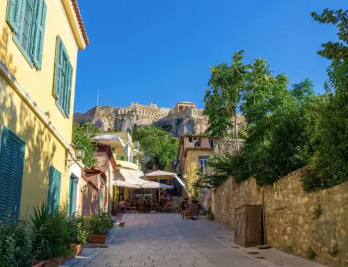
To truly appreciate Greece, you’ve got to break it down into millions of puzzle pieces. In each you will discover a fragment of history, nature and heritage woven together. It takes great care and respect to showcase these natural marvels while ensuring their preservation. Scattered around Greece are 9 UNESCO geoparks where you can appreciate the beauty while honoring the past.
What Is a UNESCO Global Geopark?
The UNESCO Global Geopark network is an effort to protect and promote sites of geological significance. These parks are single, unified geographical areas of outstanding geological heritage that are used to promote sustainable tourism and education. The idea is to celebrate the Earth’s history, showcase the incredible processes that have shaped our planet, and protect these natural wonders for future generations.
What I love the most about this concept is that it goes deeper than the surface. It’s not just about preserving the natural landscape. It’s about sustaining the geological heritage in holistic harmony with all other aspects of the area’s natural and cultural heritage. It’s about respecting and uplifting the people and communities that have built their home and vocation there. The ones who are one with the land and who grow with it. As of 2024, Greece has 9 UNESCO Global Geoparks. Let’s go find them!

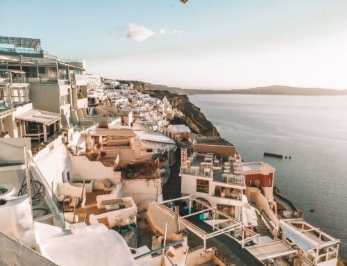
Crete Island – Mount Psiloritis UNESCO Global Geopark
We’ll start in Crete, the largest of the Greek islands. Dominating its landscape is Mount Psiloritis, or Ida, peaking at 2456 meters. It is the largest mountain in Crete with snowy peaks year-round looking down at the unique Cretan landscape.
Crete is a land of contrasts: rugged cliffs, narrow gorges, lush valleys, dense forests, palm tree beaches, hidden caves, stretches of pristine coastline, and unique species of plants. This island truly has it all. Some say Crete is a country on its own.
Psiloritis Natural Park, recognized as a geopark since 2001 and part of the UNESCO Global Geoparks network since 2015, offers a glimpse into this incredible diversity. You’ll find it in the middle of the island stretching between Heraklion and Rethymno. Across the 1272 Km2 that the geopark covers, you’ll be surrounded by nature’s creations including some of Crete’s endemic species like the Cretan arum, the cyclamen, the endemic orchids among many, many others. If you’re looking to get nerdy with the geography of Psiloritis Geopark, you can use these helpful maps to track your course through the existing road network and make it to the most notable geosites.
The Psiloritis Geopark is truly nature’s playground, in the most intimate way. You can visit the local info centers or drop by the Εnvironmental Education Center of Anogia where they host workshops and seminars to increase awareness and appreciation of the park. Depending on the season there will also be plenty of activities such as rock climbing, biking, hiking and swimming. Hiking through the many trails of the Psiolotisi geopark gives you superior views and the chance to explore at your own pace. Every path leads to a new discovery, like the enchanting (and crowd-favorite) Diktaion Andron cave, where legend has it Zeus was born.
When the sun begins to dip, drop by the Skinakas Observatory to wonder at the night sky through one of its 3 fully functional microscopes. Of course, don’t forget to treat yourself to some of the best local flavors around. If you find yourself leaving Psiloritis with an extra batch of hand-picked oregano, you can put your skills to the test with an authentic Greek cooking class in the traditional village of Vamos.

Lesvos Island – ‘Petrified Forest’ UNESCO Global Geopark
Imagine if you could hit pause on time… While us humans certainly haven’t discovered the method yet, Mother Earth seems to have done so over 20 million years ago.
It didn’t use a time machine. It was through a massive volcanic eruption that spewed lava and ash, burying everything in its path. This is the Lesvos Island UNESCO Global Geopark, formerly known as the Petrified Forest of Lesvos. You will find it in the island of Lesvos, the eighth largest island in the Mediterranean sea, a quiet destination often preferred by families for its relaxed atmosphere and enchanting nature. The park spreads across 150 km², surrounding the villages of Sigri, Eresos, and Antissa. It’s a vast, open-air museum where every step you take is a journey through time.
This fossilized wonderland of the Lesvos Geopark gives us a rare snapshot straight into the Miocene period. While many other similar petrified parks exist throughout Greece and the world (Lake Turkana Petrified Forest in Kenya or the Petrified Forest in Arizona USA), this one differs significantly. Because it’s not just the trees that were fossilized here. The entire ecosystem was covered by pyroclastic material and was silicified in place.
Roaming this park, you’ll find towering tree trunks, reminiscent of North America’s Sequoias. You will spot branches, fruits, leaves, all taking you back millions of years. This intense volcanic activity is not something surprising for the region. Thanks to its unique climate, abundant rainfall, and active tectonics, Lesvos boasts an impressive hydrographic network, featuring stunning gorges, lush valleys, and cascading waterfalls scattered across the island.
The Lesvos UNESCO Geopark is a vibrant part of the local community. Every summer, the park collaborates with women’s agrotourism cooperatives to host an agritourism festival where you can taste high-quality local products, food, and drinks, all prepared with love by the women of Lesvos. You can also visit the Natural History Museum in Sigri, which was established in 1994 to help enhance the study, management, and preservation of the petrified forest and offer further educational opportunities to the public.

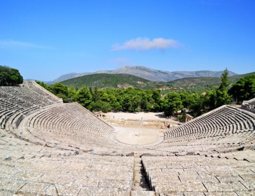
Chelmos-Vouraikos UNESCO Global Geopark
The Chelmos-Vouraikos UNESCO Global Geopark finally takes us to the mainland of Greece. It is located just 200 kilometers from Athens near the small village of Kalavrita in North Peloponnese. Kalavrita is the perfect spot to spend a few nights while you explore the region. Sitting on the slopes of Mount Chelmos you’re only a few minutes away from the world famous Kalavrita Ski Center and geosites of incredible cultural and geographical significance.
Rising to 2,355 meters, Mount Chelmos is the third highest mountain in the Peloponnese. The entire mountain range is part of the geopark, along with the stunning Vouraikos Gorge. This area was once an ancient seabed, now transformed by millions of years of geological activity that has slowly lifted it to the surface.
Chelmos-Vouraikos Geopark is a living museum of geological history. From ancient seabeds to mythical waters, every part of the geopark tells a story. Some of the most notable geosites in the area include:
Lake Tsivlou, formed by a landslide in the 20th century. is a serene alpine lake surrounded by lush forests, ideal for hiking and picnicking.
The Cave of Lakes, with its 13 underground lakes, offers an otherworldly subterranean adventure with intricate formations and crystal-clear waters.
The Waters of Styx, a dramatic cliff with a waterfall that plummets 200 meters into the Krathis riverbed, creating a striking terrace of black rocks. Steeped in mythology, the gods made their ultimate vows here, and wrongdoers met their fate. The water was said to melt any metal and be lethal to drink. Legend also claims Thetis dipped Achilles in these waters, making him nearly invulnerable (oh that heel!).
You can canoe, raft, ski, hike, and if you want to add some extra magic to your journey, try out the Diakopto-Kalavryta Cog railway. This old school, rack train system will take you on a natural roller coaster ride through steep heels and some breathtaking scenery of the surrounding landscapes.

Meteora – Pyli UNESCO Global Geopark
You’ve surely heard of Meteora. And if you haven’t, you’ve probably seen its stunning landscape on the cover of a nature magazine or as your desktop background image.
These ancient monasteries, built on pillars of towering sandstone columns have long had worldwide appeal. Recognized as a UNESCO World Heritage Site in 1988, Meteora and the stunning geosites in the region, have been added to the UNESCO Global Geopark this year
The story of Meteora’s monasteries began in the 11th century when the first eremites arrived, seeking solitude and spiritual refuge. Between the 13th and 16th centuries, these monks built twenty-four monasteries. Today, only six of these remarkable structures remain.
For many centuries, the monks relied on scaffolds to climb the rocks and haul up supplies. Over time, they switched to using nets with hooks and rope ladders, a method that not only aided their accents but also safeguarded them from unwanted visitors. These monks led lives of profound solitude, retreating to the monasteries for peace and prayer, high above the world’s distractions or as some of the founding monks describe, “between God and Earth.”
You’ll find the Meteora Global Geopark in the Thessaly region of Northwestern Greece. If you’re traveling from Athens, don’t miss a stop at Thermopylae. This narrow pass near the town of Lamia is said to have been the entrance to Hades (the underworld) in Greek Mythology. It’s also the legendary site where Leonidas and his band of brave Spartans held off the massive Persian army for three days. While it’s hard to interpret the exact numbers, historical accounts suggest that a Greek force of just 7,000 soldiers held off 70,000 to 300,000 Persians, led by Xerxes.
The nearest town to the Meteora Global Geopark is Kalampaka, which sits on the valley below Pindos Mountain. If you want a real slice of local life, you can also pitch your tent in the tiny village of Kastraki, home to less than 1,000 friendly locals. From your campsite, you’ll have a front-row seat to the jaw-dropping Meteora monasteries and all the natural beauty that surrounds them.
While the iconic Meteora monasteries are a highlight, the Meteora Global Geopark offers many more geosites to explore. You can check out the striking Gavros Landform and the unique “Adrachti” Landform, where you’ll see nature’s artistry on full display. Discover the intricate rock formations of Kalambaka’s Tafoni and witness the incredible geological processes at work.
Beyond its stunning rock formations and historical monasteries, the Geopark is a sanctuary for wildlife. It’s home to some fascinating species such as the Brown Bear, the Grey Wolf, the Alpine Chamois, the Eurasian Otter, and the rare Egyptian Vulture. These animals roam freely across the diverse habitats of the park, thriving under strict legal protection.

Grevena – Kozani UNESCO Global Geopark
Rocks, fossils, and more rocks… if that sounds like your kind of adventure, then the Grevena-Kozani UNESCO Global Geopark will fascinate you!
Spanning 2,486 square kilometers, the Grevena-Kozani Geopark is home to Greece’s oldest rock formations. The area has been recognized for its unique geological heritage and has played a pivotal role in our understanding and proof of plate tectonic theory.
There are over 122 geosites that have been recognized in the region. To the untrained eye, many of these sites might seem like ordinary stretches of land, but for researchers and scientists, they are invaluable records. The geosites mostly include ancient fossils, kaleidoscopes of rock colors, and powerful zones of tectonic movement that have molded the terrain into its current stunning form.
Sites here reveal the fascinating story of how the Tethyan Ocean formed and how Europe emerged as a separate continent. You’ll also encounter preserved sections from the Jurassic period, such as the Vourinos and Pindos ophiolites. The landscape features extraordinary landforms created by the unique combination of tectonic movements and Ice Age glaciers, including four dramatic canyons. The region is home to ancient fossils, including mammoth tusks that hold the world record for length at 5.06 meters. Additionally, you’ll see some of the youngest rocks in Greece, with soil layers that have developed over the last 4 million years, and the country’s only known hoodoos.
Beyond the rocks and trails, the region’s charming villages Grevena and Kozani await. The car ride from Athens takes around 5 hours, and just over an hour from Thessaloniki, Greece’s second largest city.

Lavreotiki UNESCO Global Geopark
If you’ve ever strolled along the sun-kissed beaches south of Athens or indulged in the mouthwatering seafood in Lavrio, you’ve probably brushed against the edges of the Lavreotiki UNESCO Global Geopark without even knowing it.
Lavreotiki is world-famous for its mixed sulfide ore deposits and historic silver extraction. It holds nearly 12% of the world’s known mineral species. The diversity here is unmatched. Spanning 177 square kilometers, Lavreotiki showcases five unique styles of ore deposits. With 48 different elements present in its minerals. No other mining district on Earth comes close.
Lavreotiki’s legacy dates back to ancient Greece, where the Athenians developed sophisticated mining and metallurgical techniques to extract silver from the rich silver-lead ores. This ancient ingenuity laid the foundation for the region’s enduring significance.
But the beauty of Lavreotiki isn’t just underground. The geopark is a biodiversity hotspot with stunning landscapes that will leave you breathless. And don’t miss the Byzantine Holy Monastery of St Paul the Apostle. This serene spot keeps the traditions of Orthodox monasticism and fresco mural painting, using natural rock-ground colors, very much alive.
Lavreotiki’s history is equally captivating. In the 5th century B.C., the mining activities here were so prosperous that they funded the construction of the iconic Acropolis of Athens. After centuries of intense exploitation, the mines fell into obscurity until the 19th century when they were rediscovered. This rediscovery, fueled by the Industrial Revolution, sparked a revival, transforming Lavrio into a vital hub of the Greek economy in the 19th and 20th centuries.
If you’re looking for some adventure seek out the Chaos Geosite. This is a giant, heart-shaped crater, located in the pine-covered Sounio National Park near Lavrio. At 55 meters deep and 120 meters in diameter, it’s a commanding sight. Some believe it was formed by a meteorite impact, while others think a collapsing cave revealed this marvel. With 25 routes ranging from 7a to 8b, it offers some of the best climbing in Greece. It’s hardcore as it is rewarding.

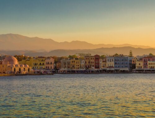
Kefalonia – Ithaca UNESCO Global Geopark
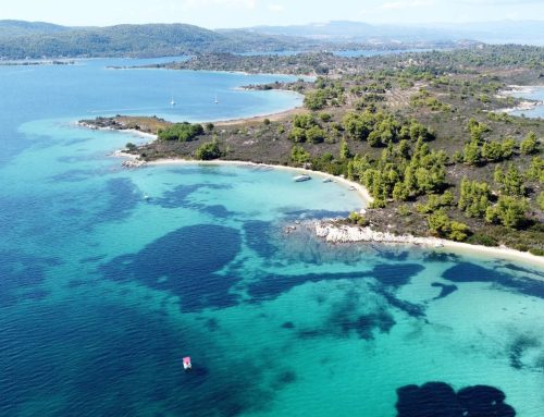
Back to the sea, but this time on the Ionian we’ll find the Kefalonia-Ithaca UNESCO Global Geopark. The Ionian Sea is a whole different character from the Aegean—like two siblings with distinct personalities. Unlike the Aegean’s deep blue, filled with myths and legends, the Ionian’s soft turquoise waters transport you to another world entirely.
The geopark is a dynamic geological playground in Europe’s most tectonically active region. Stretching across the enchanting islands of Kefalonia and Ithaca, the geopark effortlessly merges land and sea. You’ll find plenty of geological wonders to play around with: karst formations, secretive caves, dramatic sinkholes, and subterranean streams, all chronicling a history that spans over 250 million years.
Famously tied to Homer’s Odyssey as the mythical home of Ulysses, these islands are rich with historical gems. You’ll find everything from prehistoric sites and Hellenistic and Roman ruins to medieval castles and Byzantine monasteries.
Unlike most of the islands around Greece, getting to Kefalonia by ferry is not the most practical option. There are direct flights to Kefalonia from Athens and other major European cities including Paris, Amsterdam, Prague, Rome and Vienna which cut down your travel time significantly. Another option, which also gives you the chance for more stops and exploration would be to drive from Athens to the port of Patras and then take a 3.5 hour ferry ride to Kefalonia.

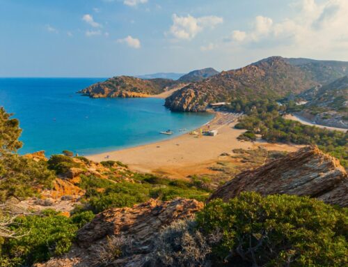
Vikos – Aoos UNESCO Global Geopark
With great heights come even greater depth at the Vikos – Aoos UNESCO Global Geopark. Nestled in the Pindus Mountain Range of Epirus, northwestern Greece, this park is a stunning mix of towering peaks, deep gorges, and rich history. Spread across over 1,200 square kilometers of unspoiled nature, it’s a paradise for explorers. Whether you’re planning on hiking along breathtaking trails or discovering hidden gems, one day simply won’t cut it. Pack your bags and plan to stay a while.
Start your journey by scaling the heights of Mt. Smolikas, Greece’s second-highest peak at 2,637 meters, or Mt. Tymfi at 2,497 meters. The two mountains give the geopark the nickname “Towering Peak Park.” The real gems, however, are the Vikos and Aoos gorges, sculpted by tectonic forces millions of years ago, providing some of the most awe-inspiring landscapes in Greece.
Explore the park’s ancient human settlements, dating back to 40,000 BC, hidden in its thickets and caves. Provatina Cave, notorious for its depth, ranks as the third deepest vertical cave in the world at 451 meters, making it a fascinating site for cave studies. Meanwhile, the famous Drakolimni, or “dragon lake,” is a picturesque alpine lake situated at an altitude of 2,050 meters. Accessible only to those willing to dedicate 9 hours for the round trip hike. Don’t forget to wander through the traditional villages and discover historical treasures from the 14th to 19th centuries, including monasteries, schools, churches, and charming arched stone bridges.
The park’s diverse ecosystems are a highlight. At lower altitudes, you’ll find evergreen shrubs and deciduous oak woods. As you climb higher, the landscape shifts to sub-Mediterranean conifers, black pines, firs, and Balkan pine woods. With over 2,000 plant species, many of which are rare and protected.

Sitia UNESCO Global Geopark
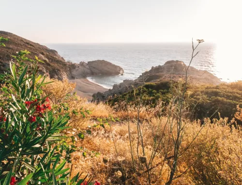
To end our tour of Greece’s 9 UNESCO Global Geoparks, we’re plunging back down to Crete. This time on the far eastern side of the island. Believe it or not, nestled between rugged coastal cliffs and Mediterranean olive groves and vineyards that produce some of the finest products, you’ll discover a palm tree forest—the only one in Europe!
This is the Vai Palm Forest in Lasithi. With over 5,000 palm trees surrounding a dreamy sandy beach, it is an undeniably unique oasis that makes you feel like you’ve entered a tropical paradise.
Surrounded by fascinating legends, the forest’s origins have been attributed to medieval Arab conquerors, Saracen pirates, or Phoenician sailors. However, scientists have confirmed that the palm trees are an endemic species, native to Crete since ancient times. Located 25 km from Sitia town and 7 km from Paleokastro village, it is easily accessible via a well-constructed and clearly signed road.
Sitia has been part of the UNESCO Global Geoparks Network since 2015, and spans 516.7 km² of geological wonders. Inside the borders you will find caves, sinkholes, plateaus, and stunning gorges. One of the highlights is its ancient fossils, including the 8.5-million-year-old deinotherium and other prehistoric mammals.
Sitia’s diverse landscape, ranging from semi-mountainous regions to coastal environments, offers fantastic hiking opportunities. The park features over 11 organized hiking routes, including sections of the international European E4 path. Popular areas for hiking include Karydi, Zakros, and the northeastern coast.
A significant part of the park centers around Karydi village, home to over 170 caves. These limestone caves, some requiring special equipment to explore, are a paradise for experienced cavers. Many remain largely unexplored, adding an air of mystery to the region.
*Disclaimer: This page might include affiliate links. If you decide to book something through one of them, I might get a little bonus, but it won't cost you anything extra.*